Category Archives: Fieldwork Blog

First solid day of diving!

Our field season is officially underway, with 2 days of work in the water under our belts. Today was our first day actually diving, with Dave Howe, Dawn Cheshaek, Bob Jimenez and myself on site. Dave graciously took boat duty, ensuring that our equipment was organized and assisting us with the tools we would need to get ourselves situated on site. The rest of us each spent about 3 hours underwater today, and a lot more time working topside. For those terrestrial archaeologists out there that often comment on the slow pace of underwater work, this is a statement well founded in fact and you’ll get no disagreement from me.

Our goals for today were to pin down the site area where we will be testing and to deploy our underwater grid. I am happy to report that both of these goals were achieved. We spent the morning and part of the afternoon examining some areas of the river that had been identified as likely candidates for the exact site location based on previous researchers descriptions, overlays of maps from old site reports, and our own observations from years past. A number of colonial brick were present in this area, and we may have found some remnants of our elusive ballast! Preliminary field identification places it as a type of Dolomite, which is not typically associated with this area.

An example of Dolomite, having a similar appearance to lithic finds on our site.

The previous maps had been rendered prior to widespread use of GPS, and without the aid of any accurate geospatial points being set nearby, so they were a little off. We were able to follow some of the clues left by previous researchers though, and found a spot matching the description to the letter. Once we settled on a location, we assembled our survey grid which will be used to help guide the excavation of test units and recording our work.

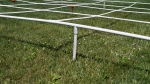
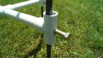
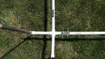
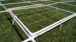
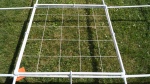
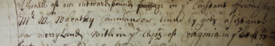
The grid is constructed of PVC pipe with 1x1m divisions. The outside perimeter uses 3/4 in. pipe, and the interior uses 1/2 in. It is staked at two points in each corner using rebar to ensure that the entire grid stays in place, in it’s direct north-south orientation. The mapping frame uses string line to divide it into 20cm squares to aid in plan view drawings of each stratigraphic layer we excavate. This will be attached to the frame using flat bungee cords to hold it in place. While this system went together very well on land, deploying it underwater caused a bit of concern. Surprisingly though, we were able to place it on site with only minor issues. The pictures above show the grid on land, for anyone wishing to use a similar system on their own sites. In total, it measures 4x8m, although it was originally intended to be 6x8m. During initial assembly, this seemed too large to be able to handle for our purposes. The grid was assembled on the beach, then pushed out to the site by divers. It was expected that it would float for a while, until it filled with water, but it actually sunk very quickly.

We did not have time today to get any pictures of it underwater, but I will try to have some in the next few days to share. Our next step is to surround the site with a floating silt curtain to help insure that our work doesn’t cause any damage to the river environment or the main channel. After this, we will be ready to get started with testing the site. We’ll update as we go, so please check back or click the follow button on the right hand side of the page to be notified via email of any updates.

Cheers,

Scott and the crew


2012 Fieldwork Presentation

Today I gave a talk to the University of Southampton’s Centre for Maritime Archaeology Research Group as part of our October Summer Fieldwork Seminar Series. The talk briefly discussed the work that we performed this past summer in the St. Mary’s River, followed by a discussion on fieldwork vs. theory and the importance of incorporating these two aspects of research in a meaningful way in order to fully assess the cultural components of archaeological study.

You can view the talk in two parts below:


First season of fieldwork complete!

Today we wrapped up the first season of fieldwork on the ballast distribution project. The site was covered by sediments and oyster beds, but we feel like we were able to get a better handle on its location, are working on creating site maps, and based on the amount of seventeenth-century artifacts in the area, believe that this site is definitely dating to that period, although the decade remains for now a mystery. Yesterday we were able to capture points on the site using a total station style transit, giving us a very accurate location for the site for future work, and today photographed and raised a few artifacts for analysis. These will be housed in the collections at Historic St. Mary’s City after treatment.

Image

I would like to extend a big thank you to a number of people for making this project happen. Firstly, Dr. Regina Fadden and Dr. Henry Miller of Historic St. Mary’s City for all of their support, financial and otherwise. Secondly, to Dave Howe and the Institute of Maritime History for supplying me with their time and equipment, allowing this fieldwork to operate smoothly and well within budget. Jim Sanborn for the generous use of his Zodiac boat, without which travel to and from the site would have been more difficult (and far less fun).  And lastly, but certainly not least, to all of the volunteers who came out to help assess and map this site: Bob Speir, Bob Jimenez, Carly Harmon, Dawn Cheshaek, and Jasmine Gollup. This work would not have been possible without any of these people, so my most sincere of gratitude to each person mentioned here.

-Scott Tucker


The site is ready for mapping!

Yesterday and today we managed to get the site staked out in the river. Buoys attached to the stakes will help us create a site map from the surface using a laser transit system, tied in to Maryland state grid points. This will give us an accurate site map with correct geo-spatial coordinates. One of our volunteers unfortunately had to return home last night, but I would like to thank Bob Speir for so graciously donating his time to the project! The all-volunteer crew working with us on this project has not only been instrumental in helping this fieldwork go forward, but they have done really amazing work. They have mostly come to us through the Institute of Maritime History, to which this project also owes a great deal of gratitude. The equipment that they have loaned to us was critical to preforming this work within a constrained budget, as we are trying to conserve much of what we currently have for the next season of fieldwork.


Fieldwork, 5 June 2012

With the site located yesterday afternoon, we spent today setting up a baseline on the site and preforming a visual survey of the site. We located a high concentration of Dutch red brick, and a number of ballast stones. 

This short clip shows what we see as we scan the site. As you can see, the river bed consists of a lot of old oyster shells.


Here are some images of artifacts we found that we believe are associated with the site:

This slideshow requires JavaScript.

Tomorrow, we will begin the task of mapping out the site, which is complicated as the majority of the site is concealed under a thick bed of oyster shells. To start, we will try to better define our baseline, and then attempt to probe for the stones. Once we have the area fully delineated, we will be shooting in the points with a shore-based TotalStation (transit) and draw this out.